Computer Science
- Machine Learning
- High Performance Computing
Remote sensing
- GIS
- Google Earth Engine
Geostatistics
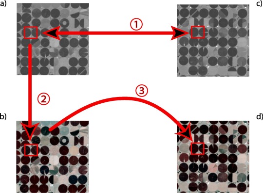
- Multiple Point Statistics
- Personal Projects
- Post-Doc
- PhD
- Me
As a Researcher (formerly Junior Group Leader) at the Institute for Interdisciplinary Mountain Research within the Austrian Academy of Sciences in Innsbruck, Austria, I bring a wealth of expertise to multiple fields, including Geostatistics, remote sensing, and Machine Learning. Prior to my current role, I was an Assistant Professor in Geo-Environmental Data Science at Utrecht University and a Postdoctoral Fellow at Stanford University. My PhD from the University of Lausanne was focused on Geostatistics, which remains a primary area of my research.
My work involves the use of Multiple Point Statistics (MPS) to simulate complex structures, while also integrating remote sensing techniques such as Google Earth Engine (for which I am a recognized Google Developer Expert) and High-Performance Computing (HPC) to advance geoscience research. I have a broad range of scientific interests and am dedicated to utilizing cutting-edge technologies in my research.
Currently, my research is focused on developing a novel passive sensing technology based on photogrammetry that can generate a digital elevation model (DEM) from a single flyover. Additionally, I am actively engaged in collaborative projects covering various subjects, including remote sensing, geostatistics, and bird tracking.
Computer Science
- Machine Learning
- High Performance Computing
Remote sensing
- GIS
- Google Earth Engine
Geostatistics
- Multiple Point Statistics
- Personal Projects
- Post-Doc
- PhD
- Me
As a Researcher (formerly Junior Group Leader) at the Institute for Interdisciplinary Mountain Research within the Austrian Academy of Sciences in Innsbruck, Austria, I bring a wealth of expertise to multiple fields, including Geostatistics, remote sensing, and Machine Learning. Prior to my current role, I was an Assistant Professor in Geo-Environmental Data Science at Utrecht University and a Postdoctoral Fellow at Stanford University. My PhD from the University of Lausanne was focused on Geostatistics, which remains a primary area of my research.
My work involves the use of Multiple Point Statistics (MPS) to simulate complex structures, while also integrating remote sensing techniques such as Google Earth Engine (for which I am a recognized Google Developer Expert) and High-Performance Computing (HPC) to advance geoscience research. I have a broad range of scientific interests and am dedicated to utilizing cutting-edge technologies in my research.
Currently, my research is focused on developing a novel passive sensing technology based on photogrammetry that can generate a digital elevation model (DEM) from a single flyover. Additionally, I am actively engaged in collaborative projects covering various subjects, including remote sensing, geostatistics, and bird tracking.